
Footsteps: Lessons From Walking Over Dry Ground On A Wet Planet
Christopher DiLeonardo, Ph.D - Senior Contributing Editor
"It is good to have an end to journey towards; but it is the journey that matters, in the end."
~ Ursula K. Le Guin, The Left Hand of Darkness
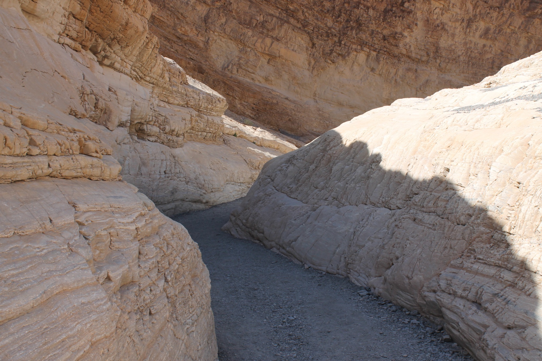
Shade, the walls of the canyon provided temporary relief from the hot rays of the late afternoon sun. I rested next to some newfound friends after starting in the late morning heading up Mosaic Canyon, a slot canyon just above Stove Pipe Wells. This was warm for April but the hike had otherwise been pleasant. I traversed up this canyon many times before, but usually constrained by schedule and a train of college students behind me never got up quite so far. This time I had been determined to explore farther, beyond the dry open wash area where the canyon widened again. As I approached the other end to a re-narrowing of the canyon I took a moment to stop and put water bottle to my lips. Hiking in the Death Valley region even in the spring can be taxing.
Death Valley, the name itself conjures visions of heat, dried bones, and crusted-salt crunching beneath each footstep. It is a vast expanse parched by a relentless sun, windswept landscapes, and an eerie lack of vegetation. The temperatures in the summer months can hover around 120 degrees Fahrenheit. This past summer in July there were 4 consecutive days of 127°F (~53°C) highs for the valley. I don’t recommend traversing this landscape during the summer. The best time of year may be in early spring when it can be pleasant shirtsleeve weather in the 70s or 80s. Most of my twenty-five excursions through the area have occurred at this time of year. And that is how it was in the spring of 2017 that I decided to venture through Death Valley on my way to the Colorado Plateau. I would never make it to the Colorado Plateau on this trek, but it would set me back on a path I was already walking, a journey of a lifetime.
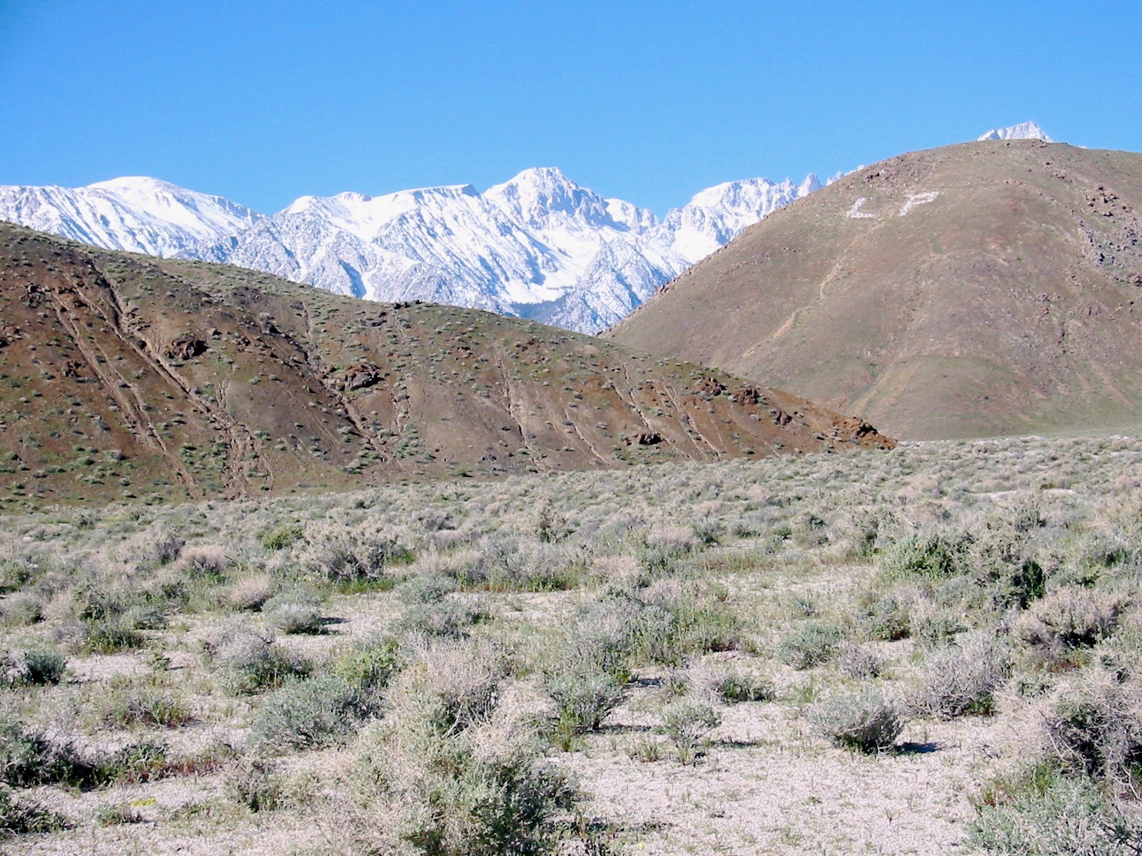
This journey started, as many do, from my home near the Central Coast of California. I had camped the night before heading into Death Valley at Diaz Lake. A spectacular area that if you’re like me you always make after nightfall and you wind up setting up your tent by headlamp. You will be taken by the sense of quiet here and the darkness. Moving away from the trees of camp to a nearby field by the lake you can also see the starry night sky in full glory. But it is waking in the morning with the crest of the Sierras and Mount Whitney rising just to your west illuminated by the low angles of the morning sun that makes this location spectacular. It also gives you clues to how Death Valley itself formed to the east and how it became the inhospitable place it is today.
Just up from Diaz Lake to the North is the town of Lone Pine, California, population just over two thousand. This is a remote place east of the Sierras that is the way station of many a traveler on their way to hike Mount Whitney. The road out of town towards Whitney Portal, heads west through a semiarid landscape. Minor crossroads off of this two-lane road bears the names of once famous icons of western movies. Roy Rogers and others have been immortalized here with so many westerns shot in the Alabama Hills just outside of town. The Alabama hills and a scar in the topography just east of them tell a story to the trained eye. A major earthquake in 1862 that killed 27, injured at least twice as many and destroyed most of the buildings in the area is recorded in this fault scarp. The hills themselves are granites the same as the Sierra Nevada just to the west brought up from deep under ground by tectonic forces. These same forces have uplifted the Sierras to their great height and tilted them westward. This granitic massif rises to over thirteen thousand feet along its crest here above Lone Pine with Mount Whitney standing at an impressive fourteen thousand four hundred ninety six feet (4,418 meters).
The height of this mountain range not only allows for spectacular photographs from the eastern side, it blocks the wind itself. The warm moist air of the Pacific travels inland from the coast. This air heavier near its base moves inland with atmospheric flow and runs right into the Sierras. This generally forces the air mass up along this western flank and with elevation becomes cooler. The air’s ability to hold moisture is dependent on temperature and as cooling increases condensation forms clouds and rain and snow follow. Much of the moisture is stripped out as the air mass makes it across the crest leaving cold, dry air. This cold dry air is heavy and sinks down the eastern slope. As it descends it now heats increasing its ability to hold moisture forming warm dry air. This rain shadow casts itself across the American southwest forming the desert landscapes that are all too familiar to weary motorists traversing the region. It seems when you travel across the deserts of the southwest, as I have many times, that this place is a primordial stark and desolate environment.
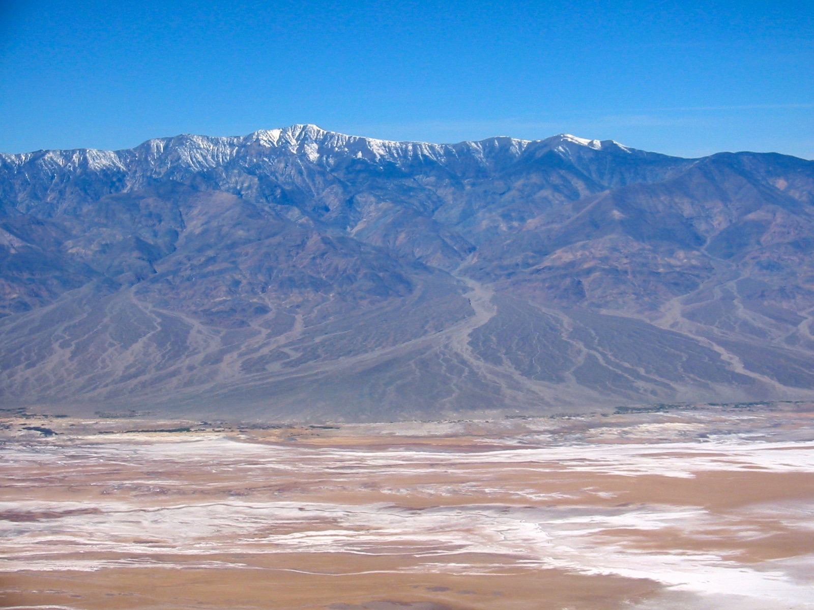
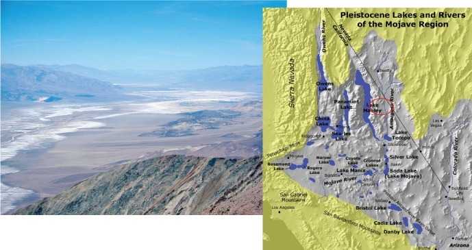
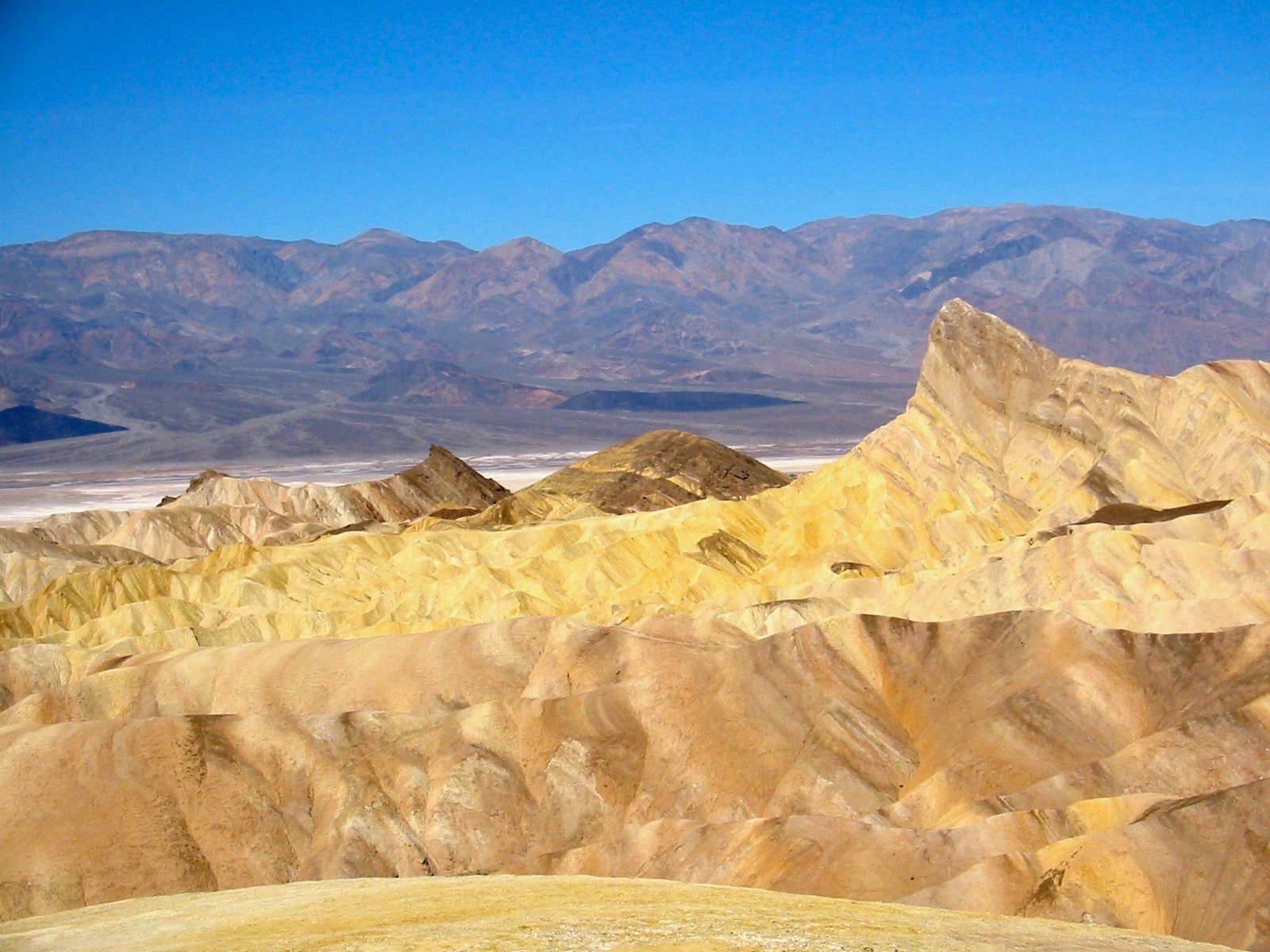
But the truth is far more complex and far more interesting. The parched desert landscape of the American southwest is relatively new in geologic history. Evidence of a once wet landscape actually sit everywhere for the trained eye. If you walk on the valley floor and head to its lowest point you stand at a shallow salty pool called Bad Water. At -282 feet (-86 meters) the water here is much saltier than that you would find on the coast and it sits at the eastern end of a salt-encrusted plain that is the floor of Death Valley.
A better perspective of this sweeping landscape is offered from 5,500 feet (1,675 meters) above the valley floor at Dante’s View. At this point we are directly above Bad Water and can see the valley floor extending to the northwest and southeast. Normally standing here is an awe-inspiring moment that connects you to both the enormity of this desert landscape and it’s dryness. The salt-covered valley floor and a landscape completely devoid of vegetation shock the eyes. But of the many times I have stood here the few times immediately following all too infrequent rainstorms suggests something else. Once while snow flurried around me I looked out at a vast lake covering the floor of Death Valley. It extended for miles in both directions. It was only a few inches deep but expansive and giving a slight window, back to a time when this was not the parched landscape we see today.
Changing Climate and Death Valley
Driving north on highway 190 seemingly out of Death Valley you come upon Beatty Junction. A turn onto Beatty Road and a short drive north brings you to a small ridge-like deposit on the right side of the road. This is Manly’s Bar. Many of my former students who made the trip into the southwest with me had been teased about this location by accompanying geologist JC and those who were returning from past trips. The “newbies” had been told after spending all day in the desert and hiking up desolate canyons, visiting salt flats, and crossing sand dunes that a “bar” was our last stop; an opportunity for a cold beer, mixed drink, or anything over ice awaited. The ploy was so convincing that many were discussing in some detail their cold beverage of choice, some with rum and accompanying parasol. Elation quickly turned to disappointment and near mutiny in some cases as we stopped in the desert environ to hike out onto… Manly’s Bar.
This low ridge is made up of gravel-rich beach deposits layered at an angle on top of more deposits. A remnant of an earlier wetter time in the area, evidence of which is everywhere in the landscape. A quick look at the slopes of the surrounding hills reveals strand lines. Each like bathtub rings marking where water lapped up on the ancient shorelines of this once massive lake. The lake here interconnected with other large lakes through the southwest. Each fed from mountain streams, heralding a much wetter age in the past.
The climate of this region has markedly changed over the last ten thousand years. The environment here during the last ice ages was wet, drying out for a few thousand years and a return to wet for about two hundred years sometime between about 4,000 to 2,000 years ago. Over the last couple thousand years drying out again completely to the harsh, desolate, and parched landscape we see today. Hard to imagine the lake and it’s surrounding environments, but it was quite different.
If you stood at the shoreline of Lake Manly about 15,000 years ago with the gentle waves lapping up along this coastline you would probably be struck by the lush beauty of the place. It would bear little resemblance to the stark otherworldly locale it is today. Seeds and pollen found in packrat middens in the area speak to forests, vegetation, and an environment maybe 14°F cooler on average. It’s shocking how the climate of this place could so drastically change over time. Equally shocking is how this parched and desolate place could get any hotter. But, the records indicate that is exactly what has been happening with increasing rates over the last few decades. Death Valley is heating up and is if this stark and desolate environment could become any more parched and barren.
It’s all about water
You might be asking at this point, in such a parched and desolate environment about the canyon I was hiking up. This is only one of many canyons incising deeply into the mountains surrounding these desert valleys. Don’t these deep canyons and dry washes speak to torrents of water? Everywhere in the region you find the evidence of rushing water carving deeply into rock.
Water shapes this desert environment. Rainfall though sparse drops into a landscape with little memory of it, hits the ground hard. Devoid of much of the vegetation that takes in water in more humid areas and a surface so collapsed overtime that soaking in simply doesn’t occur torrents race downhill. Flashfloods follow and with them debris flows of mud. The loose sand, silt, gravel and boulders mix with these floodwaters to scour through canyons deepening and widening them. Highly erosive the debris itself a mix of rocks and mud washes out of the canyons fanning out onto the desert floor. These aprons of sediment called alluvial fans sit at the base of desert-mountains throughout the region testimony to this ongoing sculpting of the landscape over time.
So in many ways this canyon above the desert floor is typical in the Death Valley region. To get up here I had swung my Jeep that morning up the gravel road above Stove Pipe Wells. I could see the plume of dust raising behind me and through it the desert floor as I gained elevation driving up the alluvial fan. I got to the parking area at the head of the fan and pulled my jeep next to other vehicles. As I knew there would be, this area is well hiked, traversed by the more hearty visitors to Death Valley in the springtime. I would have had to make other preparations if traversing up numerous other canyons in the region where foot traffic is rare.
Hiking wilderness areas alone is dangerous and should be contemplated carefully. Better to have a companion so in an emergency at least one of you can go for help for the other. When I do travel into such areas alone whether it is an extended day hike or overnight backpacking trek I let people know where I am going and when to expect me out. In the inhospitable environs of Death Valley being injured or stuck alone could mean death, as you might not be found for quite a while. That morning I was hiking alone but on a well-traveled trail. I knew that the heartier visitors and hikers in the area would be on this trail. I met a number of them during my ascent who would later be my rescue. But I was not contemplating needing any help. I have hiked for over 40 years in some of the most remote, desolate, and rugged areas of western North America. I had done so with only minor incidents, requiring stitching myself up once, tending to a few bruises and cuts several times, and being swarmed by hornets once. Never did I need to see a doctor or spend a moment in the emergency room… not even once. But I suppose luck is not always with us.
I was making my way out of the canyon, reversing my course from earlier in the day. Down a number of bathtub-slick dry waterfalls where the underlying marble was exposed. Successfully, as I had done many times before, I descended to the last small slick rock face. Beyond it the gentle-sloping gravel wash for a quarter of a mile back to the parking area and my jeep. It was late in the day and I just past friends I had made on the way into the canyon, all of them heading back now through the narrow wash. I crouched looking down the slick surface in front of me, thinking to slide down on my backside… like “an old man.” I was also thinking of sleeping that night under the starry desert sky and what I was going to order for dinner at Furnace Creek Ranch. That’s when it happened, suddenly without warning my right boot slipped out from under me and I went slamming backwards pinning my body back on top of my left leg. I fell back and down three and a half feet into an eroded crevice beneath the dry waterfall slamming the right side of my body up against jagged rock.
It is amazing what goes through your mind when you realize you are badly injured and wedged tightly in a rock crevice. Reaching forward I found my knee expecting through the pain to find bones sticking through the skin and found none. A momentary relief washed through me finding and touching my kneecap that initially I thought was shattered. But I knew through the wafting pain and the immediate swelling that it was bad. After forty years of hiking in back country without serious injury it all caught up with me in that moment. I wondered if I would ever be able to hike again and I reflected on a lifetime of trekking across remote and scenic terrain.
Lying there looking into blue sky and long shadows I thought about those terrains and what they had told me about an Earth that is ever changing. Probably nowhere on the planet is this truer than Death Valley. But it is only one place of the multitude of places that echoes the words of this lesson in the landscape and has them inscribed, deeply written in stone. The population of this ever-changing world has become increasingly distant from the natural universe that they walk through every day. They are unwary inhabitants of a planet in upheaval, and constantly changing. From earthquakes and volcanic eruptions, to the increasing threat from severe weather, firestorms, and rising sea level related to climate change the planet we live on is in flux. Much of what this world was lays eroded away in the sands of time, while we brace for the impact of a constantly changing planet on all of us who call it home. Those stories are ones I realized as I was helped out of the rock in which I was wedged needed to be shared. A lifetime of understanding gained by walking through the landscape of a changing world. My journey had not ended here but just begun. It would continue but now with a new purpose added… to share that knowledge gained while Walking Planet Earth.
Christopher DiLeonardo, Ph.D. - Senior Contributing Editor
Christopher DiLeonardo, Ph.D., is an active field geoscientist, author, and educator who brings a lifetime of geological research and adventure to his work. As an avid adventurer, he has spent decades exploring and studying some of the planet’s most remote and scenic areas. Through his role as Senior Contributing Editor for Walking Planet Earth, Dr. DiLeonardo shares the stories, insights, and field experiences accumulated over his lifetime of exploration.
Copyright C. G. DiLeonardo, 2026

Post a comment